🌊 1. The Trigger: A Massive 8.8‑Magnitude Quake
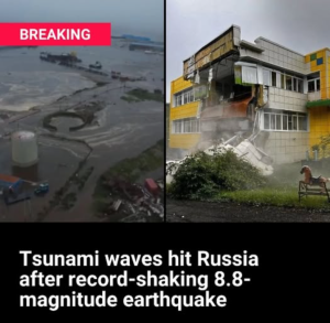
On July 29, 2025, at approximately 23:24 UTC, a powerful magnitude 8.8 earthquake struck off the southeastern coast of Russia’s Kamchatka Peninsula—one of the largest earthquakes ever recorded The hypocenter was shallow (around 11 mi / ~19 km depth), located roughly 125–315 miles southeast of Petropavlovsk‑Kamchatsky
The quake triggered alerts across the Pacific basin, touching numerous countries within hours.
2. Geographic Spread of Warnings
Russia (Kuril Islands, Kamchatka)
-
Waves as high as 3–5 meters (10–13 ft) struck the Kuril Islands, flooding coastal towns and prompting a state of emergency
-
Residents were evacuated within minutes—some areas saw wave landfall just 15 minutes post‑quake
Japan (particularly Hokkaido, Pacific coastlines)
-
Japanese authorities issued tsunami warnings for northern and eastern coasts; millions were advised to move to higher ground
-
In Hokkaido and northern Honshu, waves measured up to 1.3 m (roughly 2–4 ft), with evacuations ongoing and nuclear workers relocated from Fukushima-Daiichi as a precaution
-
Tragically, one fatality occurred in Mie Prefecture when an evacuation vehicle fell off a cliff during the rush to safety
Hawaii
-
Tsunami warnings were issued for all coastal areas; residents, including in Honolulu, were ordered to evacuate inland
-
Estimated wave heights ranged from 3–4 ft (1–1.3 m) initially, with forecasts predicting up to 4 m (13 ft) in some spots
-
Traffic gridlock occurred as people fled beaches—even roads inland. Public and private roads (e.g. Oprah’s Maui access road) were opened to support evacuations
-
Waves peaked and warnings were gradually downgraded to advisories within hours as sea levels receded
U.S. West Coast (California, Oregon, Washington)
-
The National Tsunami Warning Center issued a Tsunami Warning for the U.S./Canada West Coast including California, Oregon, Washington, Alaska, and British Columbia
-
Measured wave heights: 1.5 ft at Crescent City, 1.6 ft in Mendocino, 1.4 ft in Monterey—small but still hazardous due to strong currents
-
The warning extended along the coast; residents were cautioned to stay off beaches and marinas until risk subsided (estimated up to 30 hours)
Other Pacific Nations (Chile, Peru, Ecuador, New Zealand, French Polynesia, Guam, Solomon Islands, Vanuatu)
-
Countries including Mexico, Peru, Ecuador, Chile, New Zealand, French Polynesia, Guam, the Solomon Islands, and Vanuatu issued tsunami warnings or advisories
-
The Pacific Tsunami Warning Center warned of waves reaching 1–3 meters (3–10 ft) for many of these regions
-
In French Polynesia’s Marquesas Islands, warnings were issued for waves up to 4 m on Ua Huka, Nuku Hiva, and Hiva Oa
-
Latin American coasts were particularly warned of waves arriving as late as 12 hours after the quake, due to distance from the epicenter
3. What Each Alert Level Means 📣
Here’s a breakdown of tsunami alert levels and what to do in each:
-
Tsunami Warning: Imminent or occurring tsunami capable of causing flooding. Immediate evacuation required.
-
Tsunami Advisory: Dangerous currents or waves expected. Stay away from coastal areas; do not swim or enter water.
-
Tsunami Watch: Potential for tsunami exists but not guaranteed. Be prepared, stay informed
Hawaii and parts of the U.S. West Coast swiftly transitioned from “Warning” to “Advisory” as observed wave heights peaked and activity diminished
4. Human Impact, Evacuations & Infrastructure
-
Japan: Over 900,000 people were told to evacuate. In Fukushima, decommissioning workers were pulled from site temporarily
-
Russia (Kurils): Coastal flooding damaged buildings, infrastructure and ports. Although injured, no major casualties were immediately confirmed
-
Hawaii: Even non‑coastal neighborhoods experienced chaos—mass evacuations, traffic jams, shelters opened. Luckily, no major injuries or fatalities were reported
-
California: No deaths reported; residents were advised to avoid beaches and marinas due to dangerous currents
-
Japan’s Mie Prefecture: One woman died in a vehicle accident during evacuation, underscoring the risks even in drills
5. Historical Context & Why This Matters
-
This 8.8‑magnitude quake is one of the six strongest ever recorded, and the most powerful since Japan’s 2011 Tohoku quake (9.0)
-
It evokes painful memory of March 11, 2011 (“3.11”), when a magnitude 9 tsunami caused >15,000 deaths and triggered a nuclear meltdown—leading authorities to act with urgency this time
-
While systems like the Pacific Tsunami Warning Center (PTWC) successfully issued alerts across the Pacific, the event underscores that timely detection, warning dissemination, and public response remain vital to saving lives.
6. Timeline & Forecasted Duration
-
Earthquake struck July 29, ~23:24 UTC / early July 30 local times.
-
First tsunami waves hit Russia ~15 minutes later, Japan within 1–2 hours, Hawaii ~6–12 hours after quake, and Latin America up to 12 hours laterU.S. West Coast was warned the hazard may extend for up to 30 hours, as tsunamis arrive in multiple wave cycles over timeAdvisories began to replace warnings as observed waves diminished in Hawaii and California within several hours.
7. Key Takeaways & Safety Notes
-
Rapid detection and cross‑regional alert coordination likely prevented extensive loss of life. Evacuations in Japan occurred swiftly; shelters in Hawaii saved lives.
-
The tragedy in Mie Prefecture during evacuation highlights that even urgent pre‑emptive actions must be managed with care.
-
The global reach of the event—from Russia to Japan, Hawaii, North American coasts, Latin America, New Zealand, French Polynesia, and Pacific islands—demonstrates how interconnected the Pacific “Ring of Fire” is in seismic risk.
-
Preparedness recently emphasized includes: clear evacuation routes, timely messaging, public drills, and monitoring sea-level gauges and DART buoys.
🔍 Summary Table
| Region/Country | Alert Level | Wave Heights | Response / Notes |
|---|---|---|---|
| Russia (Kamchatka/Kurils) | Warning | Up to 5 m (10–13 ft) | State of emergency, evacuations |
| Japan (Hokkaido/Fukushima) | Warning → Advisory | 1.3 m (~4 ft); minor flooding | Millions ordered to higher ground |
| Hawaii | Warning → Advisory | Initial 3–4 ft; forecast up to 4 m | Mass evacuations; traffic congestion |
| U.S. West Coast | Warning → Advisory | ~1–1.6 ft seen; stronger currents | Beaches closed; 30‑hour risk window |
| Chile, Peru, Ecuador, NZ, French Polynesia, Guam, Solomon Is., Vanuatu | Warning/Advisory | 1–3 m (some up to 4 m) | Coastal alerts; some evacuations ordered |
Final Reflection
The July 29–30, 2025 Kamchatka earthquake triggered one of the most widespread tsunami alert systems in recent history. While damage and casualties appear limited so far, the scale of evacuation and international coordination highlight both the power of modern early warning networks and the persistent danger that seismic events pose across the Pacific.
Despite no large-scale destruction, the event serves as a stark reminder of the importance of preparedness, education, and swift action—elements that likely helped prevent a repeat of past tragedies.