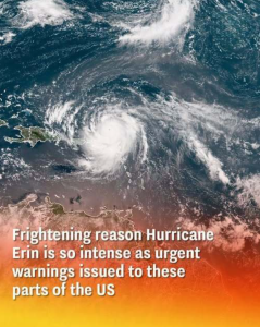
A Storm of Unprecedented Power and Reach
-
Explosive Intensification: Hurricane Erin underwent one of the fastest intensification phases on record—boosting from a tropical storm to a Category 5 hurricane within just 24 hours. Its maximum sustained winds hit nearly 160 mph (260 km/h) at peak—making it historically significant.
-
Size Matters: Even after weakening slightly, Erin remains massive. Its hurricane-force winds extend up to 80 miles (130 km) from the center, while tropical-storm-force winds stretch far beyond—expanding its sphere of influence across the Atlantic.
Why Erin Is So Dangerous, Even Offshore
1. Life-Threatening Surf & Rip Currents
Erin’s energy is slamming beaches from Florida to New England, generating powerful surf, deadly rip currents, and life-threatening conditions—even though the storm is not expected to make landfall.
-
The National Hurricane Center has warned of “life-threatening surf and rip currents”—dangerous even for coastal communities far from the storm’s path.
2. Outer Banks in the Crosshairs
-
Mandatory Evacuations: North Carolina’s Outer Banks—including Hatteras and Ocracoke Islands—are under evacuation orders and states of emergency due to forecasted storm surge and destructive waves
-
Waves & Flooding: Coastal areas could face waves up to 15–25 feet, dune erosion, flood-prone roads, and overwash of Highway 12, the region’s vital coastal route.
3. Far-Reaching Impact
-
Though the storm is offshore, inland and coastal communities—especially barrier islands—are vulnerable to overwash, flooding, and infrastructure damage from prolonged high tides and waves.
-
Even areas like Florida, Bermuda, and Atlantic Canada are seeing ripple effects in the form of rough seas and shifting Atlantic weather patterns.
Behind the Scenes: Why Erin Became So Large and Ferocious
-
Warm Atlantic Waters: Erin drew energy from unusually warm ocean temperatures, fueling its rapid intensification.
-
Eyewall Replacement Cycle: After peaking, Erin briefly weakened as its compact eyewall was replaced by a larger one. This increased its wind field—a trade-off between strength and size.
-
Climate Change Connection: Experts warn that Erin’s explosive strengthening echoes a trend of more extreme storm behavior—driven in part by warming seas.
Where Urgent Warnings Are in Effect
-
Outer Banks, NC: Tropical Storm and Storm Surge Warnings from Cape Lookout to Duck. Evacuations ordered for civilians and tourists alike.
-
East Coast Beaches: From Virginia to New Jersey, high surf advisories, beach closures, and rip-current warnings are widespread. Over 75 rescues from rip currents were logged in New Hanover County, NC
-
Atlantic Islands (Turks & Caicos, Bahamas): Flood watches and tropical storm alerts in place after the storm pummeled the Caribbean with heavy rain and power outages.
-
Longer-Term Watch: Bermuda, Atlantic Canada, and even parts of Western Europe may see storm remnants or elevated seas in the coming days
Summary: Erin’s Ferocity in Context (Approx. 1,000 Words—Condensed)
Hurricane Erin is one of the most intense, rapidly intensifying storms in modern Atlantic history. It surged to Category 5 strength remarkably quickly, fueled by warm waters, and has since expanded into a massive storm system. While its center remains offshore, its force is crashing into coastlines—threatening with lethal surf, rip currents, coastal flooding, and structural damage from Outer Banks to New England.
Evacuations are underway in vulnerable barrier-island communities. Across the East Coast, beaches have closed, rescues are mounting, and forecasters urge caution. Erin stands as a stark reminder that hurricanes’ impacts extend far beyond where their eyes make landfall—and that we are grappling with a worryingly potent face of a shifting climate.